Development of the North Staffordshire Potteries
The peculiar geological advantages of  North Staffordshire, which led to concentration on a single industry, saw the evolution of a district so analogous with the products of its manufacture that it was for centuries recognized by the name “The Potteries.” Layers of workable clays and strata of long and hot burning coal gave potters the raw materials to launch a craft that became an international industry. With few resources to develop other occupations, all the energies of the district, intellectual, scientific, and financial were directed to the refinement of pottery.
Medieval potters catered to local markets, but from the seventeenth century social and economic changes across the country created new demands for more sophisticated ceramics. Staffordshire potters rose to meet the challenge. New technologies changed the face of the industry; factories grew larger and gradually spread from the small villages of the district until the North Staffordshire Potteries evolved into a narrow, twelve mile chain of smoking bottle ovens juxtaposed with country views. As communities began to develop around the center of each major pottery-making town, from Tunstall in the north through Burslem, Handley Green (Hanley), Stoke, Lane Delph (Fenton) and Lane End (Longton) in the south, the giant, bottle-shaped ovens that characterized The Potteries landscape dominated its skyline.
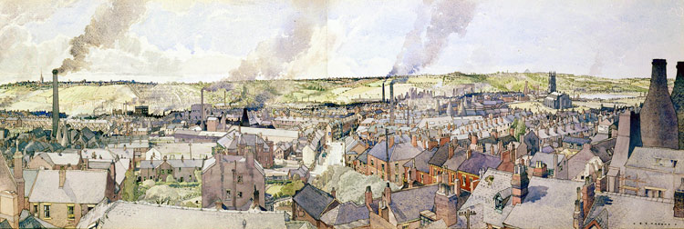
Panoramic View of Buslem warercolor, 1960s by Reginald G. Haggar
The scene looks toward Longport where many of the potters who made dark blue printed pottery had their factories.